Geotechnical investigation in Ajax forms the essential first step in any construction or land development project, providing a comprehensive understanding of subsurface conditions before excavation or foundation design begins. This category encompasses a suite of field and laboratory testing methods that evaluate soil, rock, and groundwater characteristics to ensure structural integrity, safety, and long-term performance. In a growing community like Ajax, where residential subdivisions, commercial plazas, and infrastructure upgrades are increasingly common along the Lake Ontario shoreline and inland areas, proper site investigation mitigates risks such as differential settlement, slope instability, and unexpected groundwater inflows. Without thorough subsurface exploration, projects face costly delays, redesigns, and potential safety hazards that could compromise both public welfare and investment returns.
The local geology of Ajax plays a significant role in shaping investigation strategies, as the town sits within the South Slope physiographic region of the Greater Toronto Area. Near-surface deposits typically consist of glacial till, glaciolacustrine silts and clays, and sandy sediments associated with the former glacial Lake Iroquois shoreline, which runs roughly parallel to Highway 401. These fine-grained soils can exhibit low bearing capacity, high compressibility, and sensitivity to moisture changes, demanding careful sampling and testing protocols. Deeper stratigraphy transitions into shale and limestone bedrock of the Georgian Bay and Whitby formations, where rock quality designation and fracture analysis become critical for deep foundations or underground infrastructure. The proximity to Duffins Creek, Carruthers Creek, and the Lake Ontario waterfront further introduces alluvial deposits and elevated groundwater tables that require specialized investigation techniques.
All geotechnical fieldwork in Ajax must comply with the Ontario Building Code (OBC), which references the Canadian Foundation Engineering Manual and CSA standards for site investigation practices. The Professional Engineers Act of Ontario mandates that a licensed professional engineer oversee sampling, testing, and reporting, ensuring adherence to rigorous ethical and technical benchmarks. Depending on the project scope, investigations may also follow guidelines from the Ministry of Transportation Ontario (MTO) for roadworks or conservation authority regulations from the Toronto and Region Conservation Authority (TRCA) when working near watercourses or regulated floodplains. These regulatory frameworks dictate minimum borehole depths, sampling intervals, and laboratory testing requirements that directly influence the selection of investigation methods such as exploratory test pits for shallow utility clearances or CPT (Cone Penetration Test) for continuous soil profiling in soft clay deposits common to the Ajax area.
Projects requiring comprehensive geotechnical investigation in Ajax span from single-family home additions and low-rise infill developments to large-scale municipal infrastructure and industrial facilities. Before constructing a new school, stormwater management pond, or mid-rise condominium, developers rely on SPT (Standard Penetration Test) data to correlate blow counts with soil strength parameters and estimate allowable bearing pressures. Transportation corridors such as the extension of Harwood Avenue or improvements to Bayly Street demand thorough roadbed evaluations to prevent premature pavement failure. Even smaller projects like retaining walls, swimming pools, or solar farm installations benefit from targeted investigations that identify fill materials, organic layers, or shallow bedrock that could derail construction budgets and timelines. Each investigation type contributes a distinct dataset, and experienced geotechnical engineers integrate findings to produce interpretive reports that guide foundation recommendations, earthwork specifications, and groundwater control measures.
Questions and answers
When is a geotechnical investigation required for a development project in Ajax?
A geotechnical investigation is typically required for any project requiring a building permit in Ajax, including new builds, additions, and significant renovations. The Ontario Building Code mandates subsurface investigation when foundations, retaining walls, or earthworks are proposed. Municipal site plan approval processes also demand geotechnical reports to address grading, drainage, and slope stability. Even small projects near watercourses or on fill soils may trigger investigation requirements from the Toronto and Region Conservation Authority.
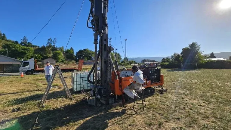
How deep should boreholes and test pits go for a typical Ajax residential project?
Borehole depths for residential projects in Ajax generally extend to at least 1.5 times the foundation width below the footing elevation, or until competent bearing strata are confirmed. In the common glaciolacustrine clays of the area, this often means depths of 6 to 10 metres. Shallow test pits for utility location or footing inspections may reach 3 to 4 metres. A qualified geotechnical engineer determines final depths based on structural loads, local geology, and Ontario Building Code guidelines.
What soil types in Ajax cause the most geotechnical challenges?
The glaciolacustrine silts and clays deposited by glacial Lake Iroquois present the most significant challenges in Ajax due to their low bearing capacity, high compressibility, and potential for long-term settlement. These fine-grained soils can also exhibit shrink-swell behaviour with seasonal moisture changes, affecting shallow foundations. Near Duffins Creek and the waterfront, loose alluvial sands and high groundwater tables complicate excavations and may require dewatering. Organic deposits in former marsh areas add further complexity.
How long does a typical geotechnical investigation take from fieldwork to final report in Ajax?
A standard geotechnical investigation in Ajax typically spans four to eight weeks from initial fieldwork to delivery of the final interpretive report. Fieldwork including drilling, sampling, and in-situ testing usually requires one to five days depending on the number of boreholes and test pits. Laboratory testing on collected soil samples adds two to four weeks for consolidation, shear strength, and chemical analysis. The engineering analysis and report preparation then require an additional two weeks, though timelines can extend during busy construction seasons or for complex projects requiring peer review.