The soil profile changes dramatically between South Ajax, with its thick lacustrine clays near the bluffs, and the sandier till deposits overlying the bedrock in the northern reaches. This geological shift, a legacy of the glacial Lake Iroquois shoreline, means a deep excavation on a lot near Pickering Village behaves nothing like a cut for a new foundation in the Rossland Road corridor. Excavation monitoring in Ajax is not a standardized checkbox; it is a dynamic interpretation of how these specific overconsolidated silty clays and water-bearing sand lenses will react to stress relief under the weight of shoring. We have seen that the real challenge here is not just measuring movement, but predicting the influence of seasonal groundwater fluctuations that saturate the upper weathered crust every spring thaw, altering the lateral earth pressures against soldier piles and lagging in a matter of days.
Effective monitoring in Ajax means interpreting the interaction between the deep Lake Iroquois clay layers and the perched groundwater systems that activate during the spring melt.
Process and scope
Local ground factors
A six-story mixed-use building on Bayly Street was advancing its shoring installation when the crew noticed a small, persistent tension crack appearing in the asphalt of the adjacent commercial parking lot, roughly 8 meters behind the wall. The initial assumption was surface desiccation, but the automated total station showed a cumulative lateral deflection of 12 mm at the top of the soldier pile, with the inclinometer profile revealing a concentration of shear strain at a depth of 9 meters—right at the interface between the sandy till and the underlying bedrock. The real danger was not the wall itself, but the potential for a rotational slide propagating from that weak interface, pulling the parking lot and its buried services into the excavation. The data triggered an immediate backfill of a critical section and a redesign of the tie-back anchor spacing. Without the real-time monitoring, that crack would have been dismissed until the lagging started to bulge. In Ajax, the difference between a cosmetic crack and a catastrophic failure often lives in the subtle trends seen in the data 48 hours before the visible damage appears.
Reference standards
CSA S832-14: Seismic risk reduction of operational and functional components, ASTM D6230-21: Standard Test Method for Monitoring Ground Movement Using Probe-Type Inclinometers, OPSS.MUNI 206: Construction Specification for Excavating, Grading, and Backfilling, MTO Field Book for Geotechnical Engineers: Monitoring Sections
Other technical services
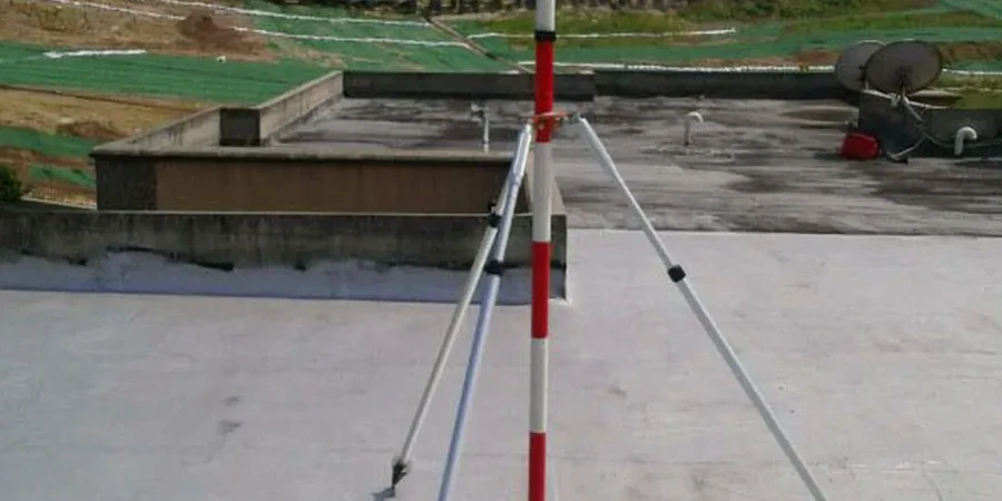
Deep Excavation Instrumentation
We deploy automated total stations (AMTS) with fixed prisms on the shoring wall, coupled with in-place inclinometers (IPIs) installed behind the wall to track the subsurface deflection profile. This dual system immediately flags any translation or rotational movement of the soldier piles in the sensitive Lake Iroquois clay.
Hydrogeological & Vibration Monitoring
We monitor the pore-water pressure regime using multi-level vibrating wire piezometers installed through the sand lenses. Simultaneously, triaxial geophones monitor peak particle velocity (PPV) to comply with the strict vibration limits mandated by Ontario Regulation 349/15 for nearby residential and heritage structures.
Typical parameters
Questions and answers
Why is vibration monitoring so strict for excavations in Ajax?
Many neighborhoods in Ajax, particularly near the waterfront and older subdivisions, were developed with masonry and unreinforced concrete block foundations that are highly susceptible to settlement from dynamic compaction or sheet pile driving. Ontario Regulation 349/15 sets low-frequency PPV limits, and our triaxial geophones capture real-time waveforms to ensure the peak particle velocity stays within the safe threshold for these fragile structures, preventing cosmetic and structural damage claims.
How often should inclinometer readings be taken during active excavation?
During the active cut-down phase, especially when passing through the water-bearing sand lenses common in Ajax, we configure the automated inclinometer systems to record data at sub-hourly intervals. The critical period is the overnight pore-pressure equalization; we have found that significant lateral creep can occur 6 to 8 hours after the last excavator bucket leaves the cut, making continuous, unattended logging essential rather than just daily manual spot checks.
What is the typical cost range for a geotechnical excavation monitoring program in Ajax?
A comprehensive monitoring program in Ajax, including the installation and 3-month monitoring of an automated total station, several in-place inclinometers, and vibrating wire piezometers, typically ranges from CA$1,120 to CA$2,940 per month depending on the number of instrument arrays and the required reporting frequency for the consulting engineer.
Can you monitor the effect of dewatering on neighboring properties?
Absolutely. Deep excavations in the sandy till deposits of Ajax often require active dewatering, which can lower the groundwater table outside the excavation footprint. We install a network of standpipe and vibrating wire piezometers around the perimeter to quantify the drawdown cone. This data is correlated with optical survey settlement markers on adjacent foundations to prove that any settlement is elastic and within the tolerable limits, not a consolidation settlement caused by the drop in pore pressure.
What is the difference between crack monitoring and automated total station monitoring?
Crack monitoring on adjacent sidewalks or walls is a lagging indicator—it tells you damage has already occurred. Automated total station (AMTS) monitoring, which we use in Ajax, tracks the 3D position of prisms mounted on the shoring wall in real time. It provides a leading indicator of movement, often detecting a 2-3 mm deflection trend long before that stress translates through the soil mass to create a visible crack on a structure 10 meters away. More info.